Early History of the Cotswolds
The river Churn comes down from the escarpment of the Cotswold hills and flows through some fairly
steep valleys to meet the Thames south of Cirencester, Gloucestershire. The area is known for its stone. Oolite limestone, a yellow
grey rock is much prized for its use in building. Along the river valley are soft deposits of fullers earth.
Humans Arrive
Scientific
research throughout the world has shown that all our paternal lines are connected somewhere in the past and that these connections
can be traced by reading the yDNA. As with maternal genealogies defined by mtDNA, men tend to cluster into a small number of groups,
18 in total, which can be defined by the genetic fingerprints of their yDNA. In native Europeans, for example, there are 5 such groups,
among Native Americans there are 4, among Japanese people there are 5, and so on. The men within each of these groups are all ultimately
descended from just one man, their clan father. Obviously, these ancestral clan fathers were not the only men around at the time,
but they were the only ones to have direct male descendants living today. The other men around, or their descendants, had either no
children at all or only daughters. These clan fathers also had male ancestral lines and these ultimately converge on the common paternal
ancestor of every man alive today. This man, know as "Y-Chromosome Adam", lived in Africa 60,000 80,000 years ago.
How far back
can the Eacott DNA be traced in England? An interesting question. From the few samples of Eacott Y chromosome DNA it appears that
all male Eacott belong to the genetic marker group R1b (hg1) This means they belong to the major western European genetic group of
which about 70% of males in Southern England belong . The haplotype is also known as the Western Atlantic Modal haplotype. These were
Paleolithic ice age hunters, Cro-magnon man who 35 000 years ago moved from Southern France (cave painters) into Spain and then to
England and western Europe and northward before the last ice age. They were known as the Aurignacian culture. Using the archaeological
record it can be seen that the Aurignacians left the Asian homeland in the Gulf area of Pakistan, moved along the Zagros Mountains
region and entered Anatolia about 47,000 years ago, crossed the then dry Straits of Bosphorus and migrated through present-day Bulgaria
up the Danube River to present-day Hungary and Austria and into Germany. Another branch had split from their Austrian relatives and
migrated to Italy from there west via the Riviera across the Pyrenees Mountains to El Castillo in Northern Spain by approximately
37,000 years ago. From there they moved into Southern England.
Atlantic Modal Haplotype gene code (AMH) DYS388,
DYS390, DYS391, DYS392, DYS393 = 12 ,24, 11, 13, 13. That is DYS388 marker is 12 etc. About 3 dozen markers and their code numbers
are used in creating matches.
So far, all Eacott tested males carry this much and more of this pattern. An alternate pattern would
shown Germanic or Viking roots.
Current research is looking at an anglo-saxon subgroup S1.
So the genetic roots of the Eacott's like
most in southern England are based on settlers from the ice age mixed with other similar males who arrived from France bearing the
same genes.
During the upper Paleolitic times there were 250 to 5000 people in Britain. This increased a little during the Hunter
times to between 3 and 20 thousand. Modest increases in the Neolithic period with up to 40 thousand, and doubling in the Bronze age
to 20 to 100 thousand. Finally the Iron age saw the population anywhere from 50 to 500 thousand people. The people 250 000 years ago,
whose height was under 5' 6" used hand axes, and used flint spears to kill Rhinos and Mammoths.
The Evidence
Homes with hearths were
used in the period 6000 years ago when the long barrows were built. At that time Avebury, Stonehenge, windmill hill and Wiltshire
and the Cotswolds were the most densely populated part of England. The soil was light and easily tilled.
In Neolithic times, 3000
to 1700 BC, long mounds or barrows were built and used for collective burial sites. One exists at North Cerney. Another ancient site
of a village exists at Woodmancote. Little is known of these people. A mace head, "Thames Pestle" was found at Eycot Wood. It was
made of polished green stone. (Now in Cheltenham Museum) The land has been farmed in some areas for 4000 years.
Leylines are
'alignments of ancient sites stretching across the landscape. Ancient sites or holy places may be situated in a straight line ranging
from one or two to several miles in length. A ley may be identified simply by an aligned placing of marker sites, or it might be visible
on the ground for all or part of its length by the remnants of an old straight track'.
One such line apparently runs from Bisley to
North Cerney (to the east). I
It is interesting to note that a line drawn on a map from Bisley Church to North Cerney Church does pass
through or very near some ancient sites: The Giant's Stone (Battlescombe), Cross Dyke (an earthwork in the valley woods), Nutbeam
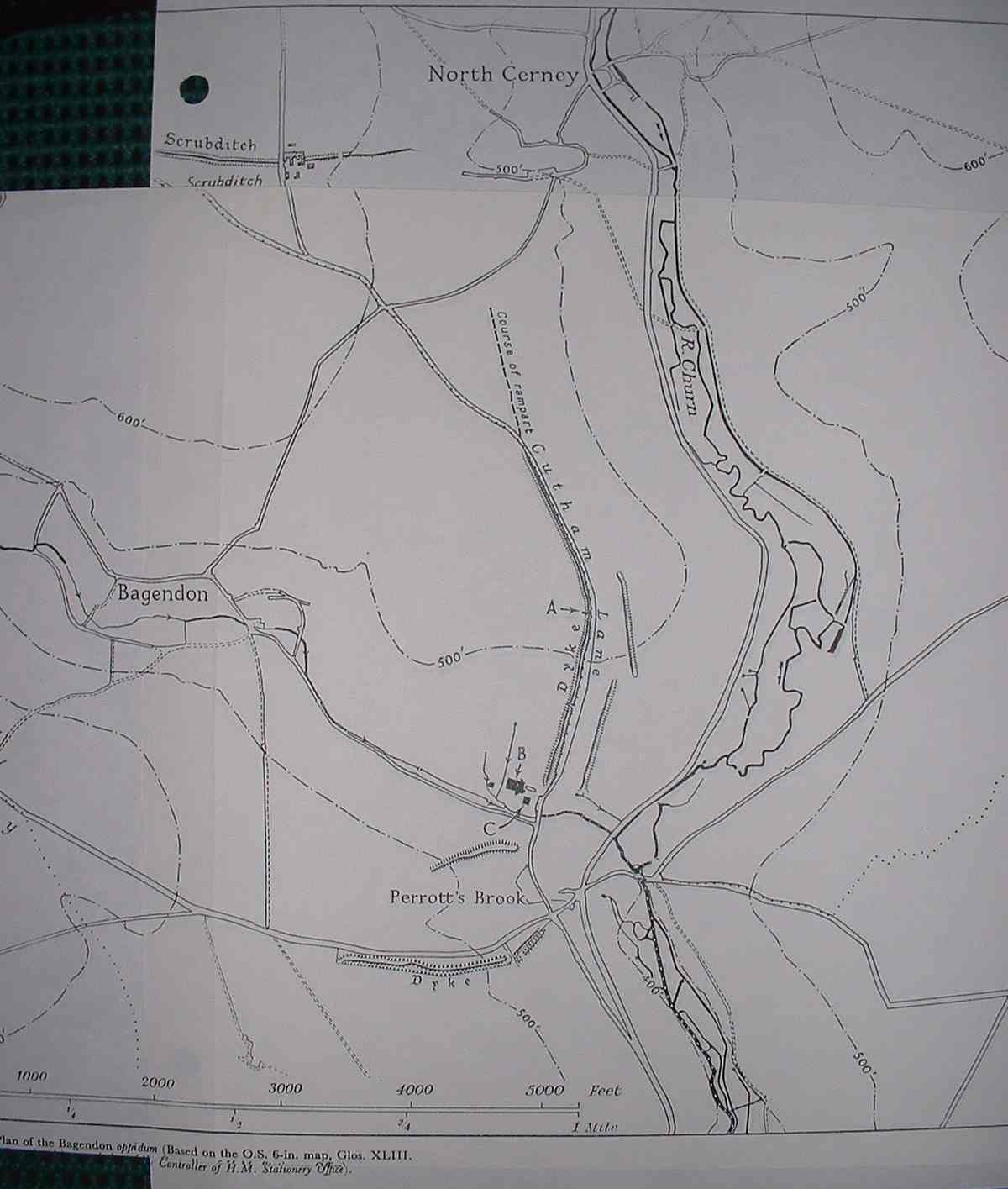
Farm (near Duntisbourne Leer), Ermin Way (the A429 Roman Road), and Scrubditch (an earthwork at North Cerney).
The Beaker folk,
named so because they made clay beakers, arrived around 1900 BC from the Rhineland in Germany. Many arrowheads were found in their
graves which indicated an unwelcome reception. The beaker folk were also noted for having quite round heads.
Iron age people, of Celtic
tribes which began moving westward from Persia about 3000 BC came to Britain around 500 BC and arrived in the Churn valley about 150
BC. They established a pattern of square fields.
The Dobunni
Around 25 BC an iron age group known generally as the Belgic
people arrived. The local group around Bagendon/North Cerney were known as the
Dobunni or Belgic Dobunni. These were a Celtic people.
Another view is that the Dobunni were a dark haired people from Iberia having come from Spain or Portugal by way of Brittany. The
hillforts and pottery at Bagendon may link to these people known as Corosolites. The Dobunni coins carried the word Corio. The name
Dobunni might in old Irish mean people with dark hair in contrast with the fairer celts. The Dobunni group set up a tribal capital
at Bagendon and traded with France and Rome.
They minted their own coins, one of the few groups to do so in England. They appeared
to have been pro Roman and readily accepted a role in the Empire. Their leader at the time of occupation was Bodvoc.
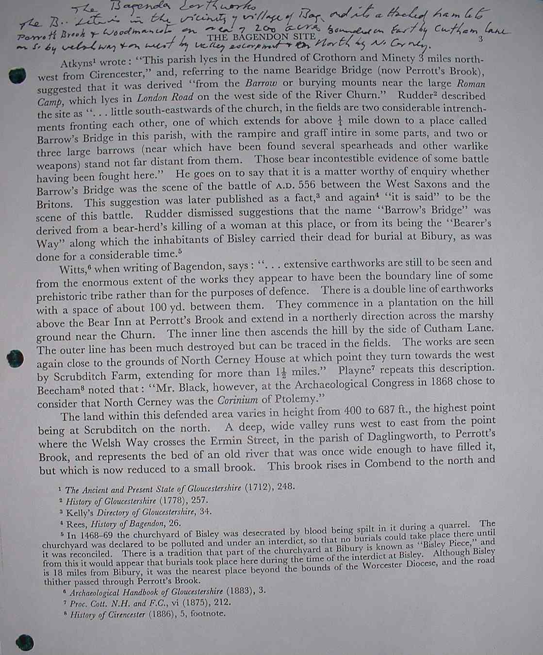
About 10 AD Bagendon
was established. A series of earthworks combined with a wooded scarp enclosed some 200 acres three miles from Cirencester. It was
an important centre for trade in metalworking. The inhabitants lived in huts with stone floors and the walls were half timbered with
wattle and daub walls. The roof was thatched. Glazed ware and glass were imported. This group had an alliance with other local tribes
at Salmonsbury and Bourton-on-the-Water which broke up about the time the Romans came. Within the next decade Bagendon was abandoned
and the Roman camp of Cirencester was set up. Any person with an Eacott name may have genes connected back to these people since Eycot
was adjacent to Bagendon.
The Romans
Roman armies and settlers came to the area between 43 and 49 AD. Aulus Plautius invaded
the Cotswolds in 43 AD and at a large battle at the Dobunni tribe fortress, which was possibly Bagendon, defeated the locals. Later,
Cirencester became
an important town, district capital for western Britain. A large number of Roman villas were established in the area. This area was
prosperous and stable until well into the fifth century.
The Saxons
In 577 the Saxons from southern
Denmark and nearby costal Germany, between the Elbe and Wesser rivers invaded and captured the
kingdom of Hwicce, a part of the kingdom
of Mercia. Both of these ancient Teutonic people came as Aryan people from somewhere near ancient Persia. The valley of the Churn
along with Cirencester was settled by the Saxons. Bagendon, Andoversford, Withington were all Saxon settlements. The British celts
were supposedly driven into Wales or forced into slavery. However the reality may be that there were not all that many Saxons, and
while they ruled, the core of the population, according to recent research, remained mostly Britons. Since Eycote was in this area
it seems likely it was also a Saxon vill. Saxon foundations, barns, and churches still survive in the area..Miserdene and Winstone
churches, in the same area, have Anglo-Saxon features. Yet, genetically the main core of the people were probably still of Romano
- Briton stock.
The Saxons Kinric and Ceawlin defeated the local Britons at Beranbyrig which was possible again the river crossing
at Perrots Brook (see development of name) and thereafter the Saxons lived in peace here for over four hundred years. They became
Christian and they set up local governments. The people of the Cotswolds in the year 700 were some of the 7,000 or so households in
the lands of the South Saxons. In 750 the church diocese of Worcester centered at Malmsbury had ecclesiastical ( religious) control
of most of the area. Winchester diocese had some areas. The area of Cirencester was part of the Ramsbury diocese. Eycote was under
the bishop of Worcester and at one time was owned by the bishop. In 680 AD the Bishop of Worcester was given his first See.
The Vikings
briefly occupied the area, capturing Cirencester and holding it for a year in the 800's, so they had little effect on the genetics
of the area.
Eycote, a manor given under an ancient Saxon charter likely traces back to the mid 800's or early 900's, probably
from the Bishop of Worcester or a Saxon king.
About 1000 AD the common administrative unit was the hundred. It was set up in 945 -
961 AD. It was a group of vills (Villagers) organized for defense purposes and to help each other out. The Saxons kept slaves but
they also practiced a form of democracy since they elected their leaders. Once each month there was a meeting of the Hundred under
the chairmanship of the hundred man. Eycote was in the centre of Rapsgate Hundred and would normally be the meeting place for the
hundred. However, at some time it was attached to Bibury hundred and so was not at all an important location.
The
Normans
All this was swept away when William the Conqueror set up a feudal system and gave the lands to his followers. All the lords
owed their allegiance to the king and lesser ranks owed allegiance to them. Slavery was done away with. Very few persons were actually
free, most had to perform duties for their lords. Most of the Saxon bishops were replaced by Frenchmen but the bishop of Worcester
was not. He retained his land holdings in the Cotswolds.
By the time of the Domesday census the area around the Churn valley was fairly
evenly populated with more people in the valleys than on the higher ground. There were a higher than usual numbers of slaves in the
area, 25 % of the people were slaves when William and the Normans arrived. The churches at Rendcomb, North and South Cerney, and Bagendon
were early Norman churches. The 12c church at Eycote was of the same time but was later closed. At Domesday, 1086, Ulward was the
Thane of Bagendon, and there were 5 yeomen and 5 slaves. Until 1792 there were still 5 freemen holdings. The land was in long narrow
Saxon style strips until the enclosure of 1792.
At the time of Domesday 1086 there were 83 listed inhabitants between Eycot, Rencomb,
North Cerney and Bagendon. This figure more likely represents households. So there were between 200 and 300 people spread along three
miles or so of the river valley. The population likely increased until the plague.
In 1327 Eycot had a population of 8 (likely 8 male
adults) and 12 in 1381. (Subsidy Roles for Cirencester, Bagendon, Woodmancote 1327, 1381) A few people were there still in 1442 the
last time a record existed for Eycote. The plague arrived in 1348-49. The Black Death spread quickly all over England. The death toll
was very high. Two rectors of North Cerney church died from it in 1348. A huge depopulation took place and many farms were abandoned.
The economy collapsed and the survivors of the plague, which came repeatedly over the next half century did very little trade. The
poor marginal lands were no longer farmed. There was no one to buy the crops. The plague struck badly in 1348-49, 1361, 1369 and with
lesser outbreaks every few years until 1480 when a severe outbreak reduced the population to less than half what it had been in 1348.
The population did not recover to the pre plague level until 1600. Peasant farmers who survived, increased the size of their farms
from an average of 12 to 30 acres. They also became more prosperous as the demand for their skills increased. The Eacotts who survived
the Black Death may have been from only one family. The village of Eycote, not on the best land was totally wiped out or abandoned.
The church was destroyed and the stone cross from it was relocated to North Cerney churchyard.
By the 14th century South Cerney was
a noted centre for the cloth trade. It had several fulling mills. Fairford, in the same area, was also known for its cloth. At Bagendon
Trinity mill survived to become part of an outdoor museum. The Cotswold sheep produced wool that was in demand in Europe and the local
farms prospered. The Tames in the 1500's, Edmund and his father were great cloth merchants. They purchased Rendcomb and Eycote and
created Rendcomb Park. During this time fields were enclosed and the modern appearance of the land took place.
"The current archaeological
picture of the Cotswolds stresses continuity, not sudden change. The Romans did not replace the Iron Age Celts in Britain, and neither
did the Saxons. Culture did not end when the Romans left Britain, and the Dark Ages were anything but dark for those alive at the
time. The Roman villas in the Cotswold area were built from the distinctive local stone and were not so very different in size or
purpose from the great manor houses which still stand. Change was slow and continuous."
(www.digital-brilliance.com/hyperg/history/
)


